- Capital: Majuro [1]
- Population: about 41,500 (2023 estimate) [2]
- Land area: 181 square kilometers (70 square miles), spread across 1.9 million square kilometers of ocean [1]
- Official languages: Marshallese and English [1]
- Currency: United States dollar [1]
- Geography: 29 coral atolls and 5 single islands in the central Pacific, the only sovereign nation composed entirely of low-lying coral atolls [3]
Here's something that'll ruin the next geography quiz you take: the Marshall Islands has more sovereign ocean than the entire land area of Mexico, and less actual land than the city of Boston. I had to look this up twice. The whole country fits inside 70 square miles, but it claims a maritime zone bigger than Alaska, Texas, and California combined. That ratio of land to sea is the highest of any country on Earth.
A Country Made of Coral Rings
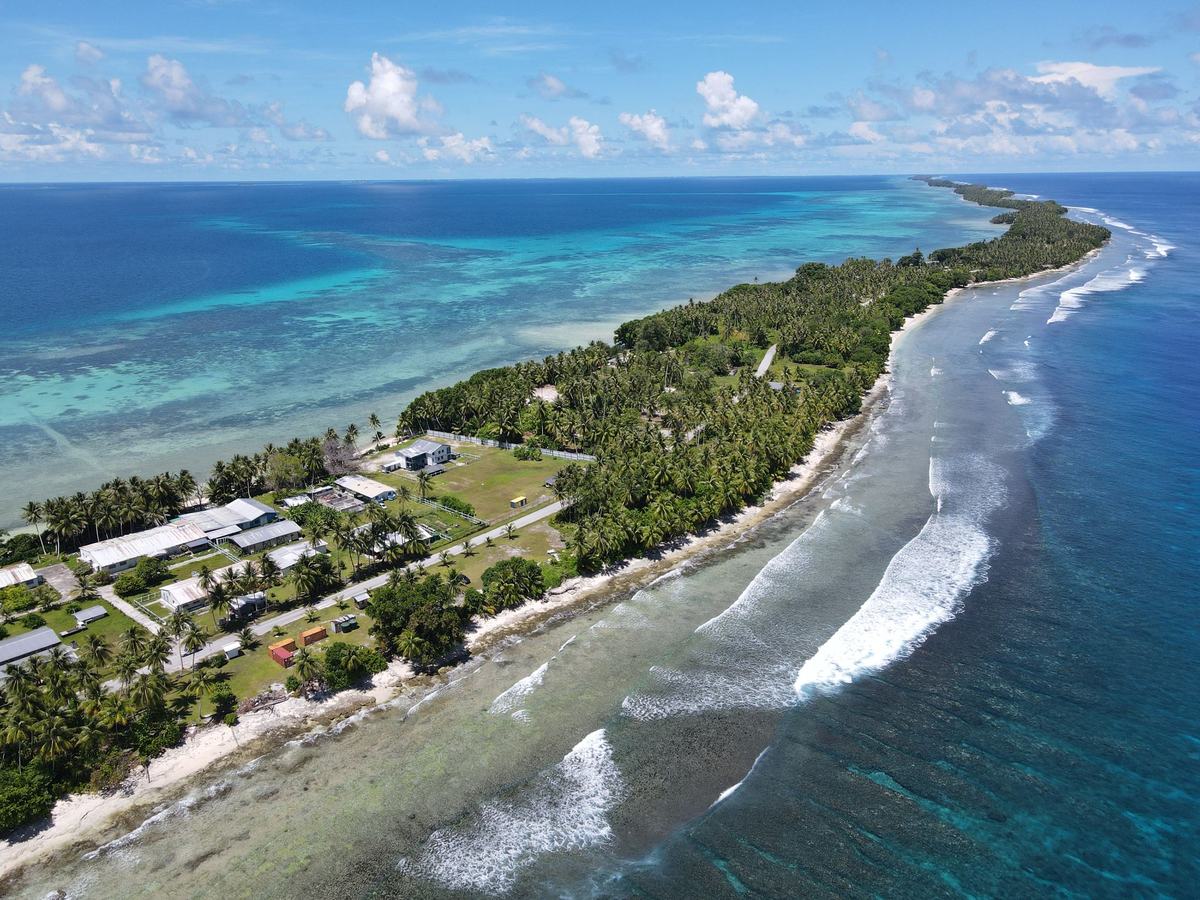
A Marshall Islands atoll is not what most people picture when they hear "island". There's no mountain, no interior, no inland anything. An atoll is a ring of coral sitting on top of a long-dead volcano that sank back into the sea millions of years ago. The coral kept growing as the volcano sank, and what's left is a thin necklace of land around a lagoon. The highest natural point in the entire country is about 10 meters above sea level. That's roughly the height of a three-story building, and it's the tallest thing in the nation.
Bikini Atoll, Kwajalein, Majuro, Enewetak. The names sound like songs because in Marshallese they sort of are. Marshallese is a Micronesian language with a writing system that wasn't standardized until the 1970s, which means older maps spell the same atoll three different ways depending on who showed up first with a clipboard.
Stick Charts and Star Paths
Long before GPS or even European contact, Marshallese navigators were crossing hundreds of miles of open ocean using something called a rebbelib - a chart made of palm sticks and cowrie shells. Which, if you think about it, is one of the most elegant pieces of indigenous technology ever made. The sticks didn't represent the islands themselves. They mapped the swells. The way ocean waves bend around landmasses, the way they collide and form patterns hundreds of miles from the nearest shore. Navigators memorized these patterns and read them by lying flat in their canoes, feeling the rhythm through their bones.
Western explorers thought these were decorative for years. Turns out they were navigation manuals more sophisticated than anything Europe had for open-ocean travel. Real ones are now in museums in Honolulu, Berlin, and Majuro itself, and the knowledge of how to actually read them is held by maybe a dozen people alive.
Bikini Atoll and a Heavy Chapter
Most people couldn't find the Marshall Islands on a map, but they've heard of Bikini Atoll - usually without knowing where it actually is. Between 1946 and 1958, the United States detonated 67 nuclear weapons in and around the Marshall Islands. The largest, Castle Bravo in 1954, was a 15-megaton hydrogen bomb. About a thousand times the power of Hiroshima. The fallout drifted east and contaminated inhabited atolls that scientists had claimed were safely outside the danger zone.
The people of Bikini were relocated in 1946 with the promise they could return when testing ended. They have never gone back. Rongelap, Utirik, and Enewetak all dealt with displacement and serious health consequences. The Compact of Free Association between the Marshall Islands and the United States, signed in 1986, includes ongoing compensation, but the issue is far from settled. The bikini swimsuit, by the way, is named after the atoll. The designer thought his invention would have an explosive cultural impact. He wasn't wrong about the explosive part, just wrong about which one mattered.
A Strange Political Arrangement
The Marshall Islands is a fully independent country, but its relationship with the United States is unusual. Under the Compact of Free Association, Marshallese citizens can live and work in the U.S. without a visa, the U.S. provides defense, and the U.S. dollar is the currency. In exchange, the U.S. leases Kwajalein Atoll as a missile testing range and military installation. The site is used to track intercontinental ballistic missiles fired from California. So in one corner of the country, traditional fishermen are paddling outrigger canoes. In another, the Pentagon is calibrating its strategic deterrent. Same nation. Same week.
The Climate Reality
The average elevation of the Marshall Islands is about two meters above sea level. Read that again. Two meters. When climate scientists talk about which countries are most threatened by rising seas, the Marshall Islands isn't on a list. It is the list. Saltwater intrusion is already poisoning groundwater on outer atolls. King tides flood the airport runway in Majuro on a regular basis. The country has become one of the loudest voices in international climate negotiations, partly because it has to be. There is no higher ground to retreat to. The whole country is the coast.
Frequently Asked Questions
Where are the Marshall Islands located?
The Marshall Islands are in the central Pacific Ocean, roughly halfway between Hawaii and Australia, just north of the equator. The country sits east of Micronesia and west of Kiribati, scattered across about 750,000 square miles of open sea.
What language do people speak in the Marshall Islands?
Marshallese and English are both official languages. Marshallese is spoken at home and in daily life by nearly the entire population, while English is used in government, business, and schools. Younger Marshallese typically speak both fluently.
Is the Marshall Islands a U.S. territory?
No. The Marshall Islands is a fully sovereign nation that gained independence in 1986. It has a Compact of Free Association with the United States, which provides defense and economic support in exchange for U.S. military access, but it is not a territory.
Can you visit Bikini Atoll?
Technically yes, but it is extremely difficult. Bikini Atoll is a UNESCO World Heritage Site and small numbers of divers visit each year to see sunken warships from the nuclear tests. The atoll remains uninhabited due to lingering radiation in the soil.
How big is the Marshall Islands?
The total land area is about 181 square kilometers, roughly the size of Washington, D.C. However, the country's exclusive economic zone covers about 1.9 million square kilometers of ocean, making it one of the largest maritime nations on the planet by sea area.
Sources
- The World Factbook: Marshall Islands - Central Intelligence Agency
- Marshall Islands Country Profile - World Bank
- Bikini Atoll Nuclear Test Site - UNESCO World Heritage Centre
- Marshall Islands Stick Charts - Smithsonian National Museum of Natural History
- Compact of Free Association - U.S. Department of the Interior, Office of Insular Affairs